About 6 Days Kilimanjaro Hiking Machame Route
The 6 Days Machame Route is one of the most scenic and popular paths to summit Kilimanjaro. Known as the 'Whiskey Route', it offers climbers a varied landscape, starting with lush rainforests, transitioning through alpine deserts, and culminating in breathtaking panoramic views from the summit. While challenging, it provides ample time for acclimatization, making it a favorite among trekkers seeking both adventure and a rewarding climbing experience
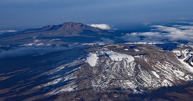
The route approaches Mount Kilimanjaro from the south, beginning with a short drive from Moshi to Machame Gate. The path leads hikers through the rain forest to Shira Plateau. Here, many of Kilimanjaro's routes converge. Then the route turns east and traverses underneath Kilimanjaro's Southern Ice Field on a path known as the Southern Circuit before summiting from Barafu. Descent is made via the Mweka route. Kitano Tours And Safaris® offers 6 days & 7 days Machame route as a seven day group climb or as a six day private climb. The six day variation combines days four and five, going from Barranco Camp to Barafu Camp without staying at Karanga.
The Success Rate of Climbing | Hiking Kilimanjaro 6 Days Machame Route
The presence of a knowledgeable guide and a reliable support team greatly contributes to the success rate of climbers on the Machame route. Their expertise and assistance ensure climbers can navigate the challenging terrain, stay safe, and make the necessary adjustments for a successful summit attempt.
With the guidance and support of experienced professionals, the success rate for climbers on the Machame route in six days ranges from 80% to 90%. This high success rate is a testament to the importance of having a competent team to rely on throughout the expedition.
What is the difficulty level of the 6 days Machame route package?
The Machame Route is renowned for its difficulty, primarily due to the altitude challenges that climbers face along the way. The steep terrain, combined with the high altitude, tests the endurance and stamina of even the most experienced hikers. One of the main difficulties climbers encounter on the Machame Route is the steep terrain. The path is characterized by steep slopes and rocky sections, which require climbers to exert significant effort and maintain a steady pace. The continuous uphill climb can be physically demanding, especially for those who are not accustomed to such challenging terrain.
6 Days Hiking Machame route Cost
| No of PX | Price | Tour Type |
| 1 PAX | 2500 | Luxury Tour |
| 1 PAX | 1,600 | Private Tour |
| 5 Pax and More | 1,450 | Group Joining |
Machame Route Itinerary 6-7 Days
Machame is one of the most popular routes of Kilimanjaro.Amongst the few old Kilimanjaro trekking routes, Machame is the prime one. Not only the oldest route but also Machame Route is the most populous one. The hiking via Machame starts at the rainforest zone and further traverse through rest 4 climatic zones.
>>> The drive from Moshi to the Machame Gate takes about 50 minutes. The journey passes through the village of Machame which is located on the lower slopes of the mountain. As we leave the park gate, we walk through the dense rain forest on a winding trail up a ridge until we reach the Machame Camp.
>>> We leave the glades of the rain forest and continue on an ascending path up to a steep, rocky ridge. On the Shira Plateau, we pass through heather and open moorlands, then cross a large river gorge to Shira 2 Camp.
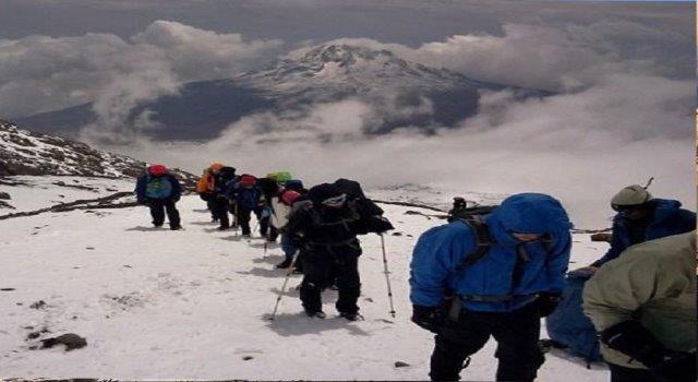
>>> We continue to the east up a ridge and then head southeast towards the Lava Tower - a 300 ft tall volcanic rock formation. We descend down to Barranco Camp through the strange but beautiful Senecio Forest to an altitude of 13,000 ft. Although you begin and end the day at the same elevation, the time spent at higher altitude is very beneficial for acclimatization..
>>> We begin the day by descending into a ravine to the base of the Great Barranco Wall. Then we climb the non-technical but steep, nearly 900 ft cliff. From the top of the Barranco Wall we cross a series of hills and valleys until we descend sharply into Karanga Valley. One more steep climb up leads us to Karanga Camp. This is a shorter day meant for acclimatization..
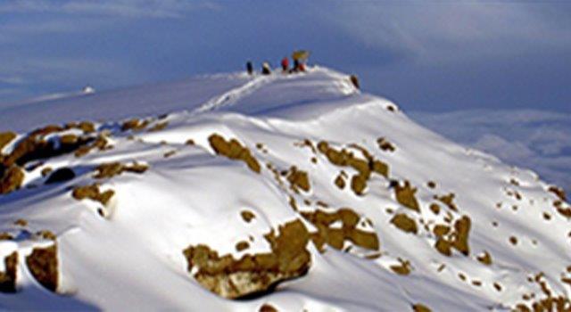
>>>> We leave Karanga and hit the junction which connects with the Mweka Trail. We continue up to the rocky section to Barafu Hut. At this point, you have completed the Southern Circuit, which offers views of the summit from many different angles. Here we make camp, rest and enjoy an early dinner to prepare for the summit day. The two peaks of Mawenzi and Kibo are viewable from this position.
Very early in the morning (around midnight), we begin our push to the summit. This is the most mentally and physically challenging portion of the trek. The wind and cold at this elevation and time of day can be extreme. We ascend in the darkness for several hours while taking frequent, but short, breaks. Near Stella Point (18,900 ft), you will be rewarded with the most magnificent sunrise you are ever likely to see coming over Mawenzi Peak. Finally, we arrive at Uhuru Peak- the highest point on Mount Kilimanjaro and the continent of Africa.
From the summit, we now make our descent continuing straight down to the Mweka Hut camp site, stopping at Barafu for lunch. The trail is very rocky and can be quite hard on the knees; trekking poles are helpful. Mweka Camp is situated in the upper forest and mist or rain can be expected in the late afternoon. Later in the evening, we enjoy our last dinner on the mountain and a well-earned sleep.
On our last day, we continue the descent to Mweka Gate and collect the summit certificates. At lower elevations, it can be wet and muddy. From the gate, we continue another hour to Mweka Village. A vehicle will meet us at Mweka Village to drive us back to the hotel in Moshi.